In an era where precision is paramount, Real-Time Kinematic (RTK) GPS technology stands out as a revolutionary force in mapping and surveying. This advanced technology has redefined the standards of professionals across various industries. Let’s delve into the intricacies of RTK GPS, exploring its principles, applications, and significant impact on geospatial data collection.
Understanding RTK GPS
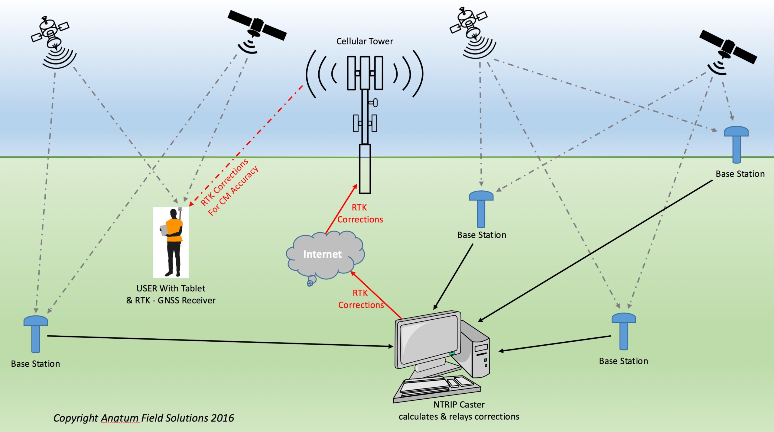
What is RTK GPS?
At its core, RTK GPS is a sophisticated satellite navigation technique designed to significantly enhance the precision of position data obtained from satellite-based positioning systems. Utilising a fixed base station, which accurately broadcasts differential corrections to a mobile receiver, enables the receiver to calculate its position with remarkable centimetre-level accuracy in real time. This process not only drastically improves the accuracy of location data but also ensures that this high precision is maintained consistently, thereby revolutionising tasks that require utmost spatial accuracy and reliability in diverse applications ranging from surveying and construction to agriculture and environmental monitoring.
How Does It Work?
RTK GPS operates on correcting the inherent errors associated with the Global Positioning System (GPS) signals. Various factors, including atmospheric interference, satellite orbit inaccuracies, and timing issues, can cause these errors. RTK GPS systems can effectively mitigate these errors, providing highly accurate position data to the mobile receiver.
Applications of RTK GPS in Mapping and Surveying
The advent of RTK GPS has significantly transformed mapping and surveying. Its ability to provide real-time, high-precision data has made it an invaluable asset in various applications.
Precision Agriculture
In agriculture, RTK GPS enables farmers to conduct precise field mapping, soil sampling, and crop scouting. This technology allows for implementing precision farming practices, optimising inputs and increasing crop yields.
Construction and Engineering
RTK GPS facilitates accurate site planning, earthmoving, and structural alignment for construction and engineering projects. It ensures that structures are built precisely according to design specifications, minimising errors and reducing the need for costly corrections.
Environmental Studies
In environmental research, RTK GPS is crucial in monitoring landscape changes, tracking wildlife, and managing natural resources. Its precision aids in collecting reliable data for studying ecological patterns and assessing environmental impacts.
The Impact of RTK GPS on Surveying and Mapping
We are integrating RTK GPS into surveying and mapping practices, project efficiency, and cost-effectiveness.
Enhanced Accuracy
The centimetre-level accuracy RTK GPS systems provide is a game-changer for surveying and mapping professionals. It allows for the creation of highly detailed and accurate maps, essential for planning, analysis, and decision-making.
Increased Efficiency
With RTK GPS, the time required for field data collection is significantly reduced. Surveyors can now obtain precise measurements quickly, enabling faster completion of projects and timely delivery of results.
Cost Reduction
The efficiency and accuracy of RTK GPS technology also contribute to substantial cost savings. By reducing the need for repeated measurements and minimising errors, projects can be completed within budget and with fewer resources.
Global GPS Systems: A Catalyst for RTK GPS Adoption
The availability of global GPS systems has facilitated the widespread adoption of RTK GPS technology. These systems provide the necessary infrastructure and satellite coverage to support RTK GPS operations worldwide. As a result, professionals in diverse geographical locations can leverage the benefits of RTK GPS, enhancing the quality and reliability of their work.
Challenges and Future Directions
Despite its numerous advantages, RTK GPS technology faces challenges, including signal obstructions in dense urban areas or under heavy canopy. Moreover, the initial setup cost and the need for continuous access to a base station network can be prohibitive for some users.
However, ongoing advancements in GNSS (Global Navigation Satellite System) technology and the development of alternative correction services are addressing these challenges. Innovations such as multi-frequency receivers and the integration of complementary technologies are expanding the applicability and accessibility of RTK GPS.
Conclusion
RTK GPS has undoubtedly revolutionised the fields of mapping and surveying, setting new standards for precision, efficiency, and reliability. Overcoming the limitations of traditional GPS technology has opened up new possibilities for professionals to conduct their work with unprecedented accuracy. As technology continues to evolve, the future of RTK GPS looks promising, with the potential to further enhance our understanding of the world and our ability to manage it effectively. In this ever-changing landscape, RTK GPS is a precise and informed future.